What Agricultural Robots Can Do on Complex Terrains? Uphill, Downhill, Turning & Selection Tips
Many agricultural robots perform brilliantly in flat terrain test fields, but they falter on slopes, terraces, and under forest canopies. Only machines capable of traversing hills, terraces, and avoiding tree roots are truly viable for the rural market. This article clarifies the issues: Why is complex terrain challenging? How to choose between wheeled, tracked, and walking robots? How to locate without GPS? How to prevent tipping when turning and going uphill? It also provides a practical selection and testing checklist to facilitate pilot implementation by governments, industrial parks, and equipment engineers.
Slope, loose soil, terraces, tree roots, and obstructions simultaneously test mechanical, control, and positioning systems—a well-executed system is a testament to engineering prowess; a poorly executed one is merely a "purely decorative" prototype. In recent years, academia and engineering have focused on these "real battlefields," resulting in numerous studies on terrace path planning, slope stability control, and SLAM fusion under GNSS limitations, providing us with actionable deployment roadmaps.
01 Why is complex terrain more difficult than flat terrain? Three core pain points:
Kinematics and traction conflict: Traction is limited uphill, and slippery or wet slopes easily cause slippage; braking and counter-propulsion are needed downhill, and rollover torque is generated when turning. Typical wheeled robots are prone to instability in these situations.
Location and perception limitations:Shrub canopies, forest canopies, or terraced walls can block GNSS signals; LiDAR and vision are also interfered with by low vegetation, strong backlighting, or multiple obstructions. This necessitates the fusion of perception (vision/inertial navigation/LiDAR/IMU) and more complex localization algorithms.
Path planning and boundary issues: Terraced fields are often irregular small plots, and the walking path needs to consider step transitions, access to and from the site, and the spatial constraints of the work tools and terrain (e.g., the workspace of the seeding/spraying arm).
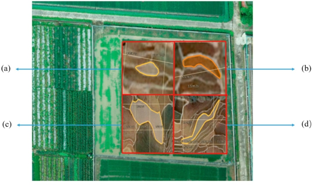
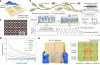
Image source: MDPI "Path Planning for Rice Seeding Robots in Hilly Terraced Fields"
Configuration file and numbering of field blocks for verification testing. (a) A field block representing the outline of simulated field block 1; (b) A map representing the contour lines of simulated field block 2; (c) A plot representing the outline of simulated plot 3; (d) A plot representing the outline of simulated plot 4.
02 Tracked / Wheeled / Foot-Mounted—Advantages and Disadvantages of Three Chassis Types
The advantages and disadvantages of the three chassis types are explained below, along with recommended slope ranges (for quick on-site selection).
1) Wheeled
Advantages: High efficiency, low energy consumption, low maintenance costs, high speed, suitable for flat or slightly sloping terrain.
Disadvantages: Poor grip and lateral stability; prone to slipping and tipping over on soft or muddy slopes.
Recommended slope: 0–15° (0–27%) is ideal, up to 20° under good road conditions.
Applicable scenarios: Leveling orchards, greenhouses, and slightly hilly areas.
2) Tracked
Advantages: Low ground pressure, good grip, strong traction, more stable than wheeled vehicles on soft and steep slopes. Many slope-specific robots use wide tracks or self-stabilizing platforms (SlopeHelper example).
Disadvantages: Generally higher energy consumption than wheeled vehicles, larger turning radius, potentially more severe ground disturbance and soil compaction (depending on track design). Maintenance of chain/track components also incurs costs.
Recommended slope: 15–35° (approximately 27–70%). Some dedicated tracked platforms can operate on steeper slopes (depending on self-stabilizing design).
3) Legged/Wheel-legged/Hybrid
Advantages: Strong traversing ability, capable of crossing steps and large root systems, suitable for highly irregular terrain. Recent research is also exploring the use of wheel-leg hybrids for slope tracking (wheel-leg robots).
Disadvantages: Complex structure, higher control difficulty, greater cost and reliability challenges; currently more in the research and prototype stages than large-scale commercialization.
Recommended slope: Suitable for extremely steep and complex terrain (>35°), but commercial availability requires careful evaluation.
Quick assessment method: If the main slope of the plot is<15° and="" the="" road="" network="" can="" be="" modified="">
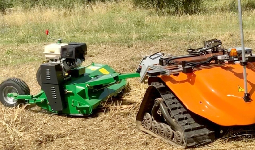
Image from sciencedirect, "Evaluating an autonomous electric robot for real farming applications"
03. Location: What to do when GNSS is unreliable?
In forest, terraced walls, or canyon terrain, GNSS signals will be attenuated or subject to severe multipath propagation. The following are several commonly used and academically validated alternative/fusion methods in engineering:
A. Multi-sensor fusion SLAM (Visual/Lidar + IMU)
Method: Combining visual odometry (VIO) or laser odometry (LIO) with an inertial measurement unit (IMU) to form stable short-term localization; then loosely or tightly coupled with RTK/GNSS to create redundancy. Recent research shows that SLAM/GNSS fusion can significantly improve stability in weak signal environments.
B. Terrain matching/visual odometry + terrain reference map
Method: With known terrain (aerial photography or laser altimeter DEM), real-time matching of visual or LiDAR features with a reference terrain is used to calibrate localization. This method is effective for mountainous/terraced terrain with distinct features.
C. Inter-robot fusion
Method: A swarm of robots observes each other or mutually locates each other via beacons (e.g., using UWB, camera recognition, or VIO mutual alignment), incorporating formation as part of the localization redundancy. A recent ArXiv work proposes a degradation-aware multimodal GNSS/SLAM collaborative method for GNSS degradation scenarios.
D. Ground Base Stations and Visual Markers (Local RTK/Beacon)
Approach: Deploy a small number of ground base stations or visual markers (AprilTags, etc.) in terraced fields or orchards to provide robots with local high-precision references, especially suitable for demonstration sites or controlled parks. Simple to implement and cost-effective.
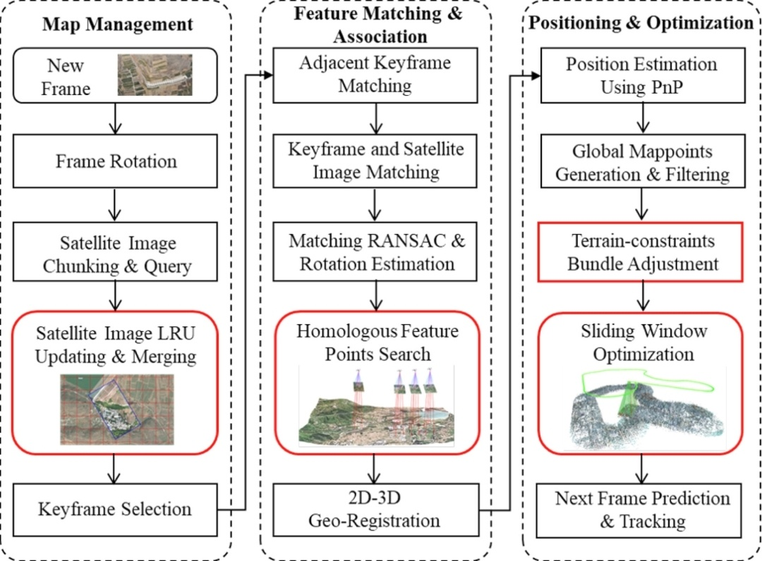
Image from sciencedirect, international journal of Applied Earth Observation and Geoinformation, "GNSS Denial-of-Service Geolocation for UAVs Based on Terrain-Weighted Constraint Optimization"
04 Stability Control and Path Planning: Engineering Practices for Uphill, Downhill, and Turning
Slope Speed Management: Reduce speed and use torque control when going uphill to avoid wheel spin; use regenerative braking/tow braking when going downhill to prevent loss of control. The controller needs to integrate steep slope detection (IMU pitch angle threshold) and trigger a safety mode.
Side-tipping prevention: Real-time estimation of center of gravity position and lateral moment (combined with IMU and load sensing). Automatic speed limiting or path rerouting when lateral moment approaches a safety threshold.
Step/terrace transfer strategy: When encountering steps, a strategy of "approaching the edge—crossing at an angle—reversing and retrying" is adopted, or a variable attitude platform (lifting/tilting) is used to traverse the steps. Some dedicated platforms are designed as self-stabilizing platforms, capable of maintaining operation on slopes of 30°+.
05 Real-world cases and searchable engineering examples
SlopeHelper / Dedicated tracked platform: Projects have demonstrated its self-stabilizing lateral platform and wide tracks enabling operation in extremely steep vineyards, claiming adaptability to slopes of 30°–45° (detailed reports in industrial media). This type of machine ensures safe operation through hardware self-stabilization combined with sensing.
Terraced field planting path planning: A path planning algorithm suitable for small and irregular terraces is proposed, emphasizing a general method for boundary detours and step-advance/retreat, which can be used as a reference for pilot projects of terraced field robots.
Under-canopy navigation research: This study proposes visual navigation methods for navigating under crop canopies, including visual solutions and datasets for scenarios with limited GNSS and dense obstacles. It is highly relevant for robots navigating in forests or orchards.
In summary, the following recommendations for landing platform selection are provided:
Loose soil, often muddy + slope 15–30°: Recommended: Tracked (wide tracks, self-stabilizing platform preferred).
Large plots with gentle slopes (<15°) and="" high="" speed="" requirements:="" recommended:="" wheeled="">
Plots with many steps, requiring crossing rocks or root systems: Recommended: Wheeled-legged or hybrid wheel-tracked platform (if budget allows).
GNSS is severely limited (forest/canyon) → SLAM (LIO/VIO) + IMU fusion is necessary, or local base stations (UWB/visual markers) must be deployed.
Complex terrain is not a problem that a single machine can solve, but rather a testing ground for a complete system engineering project involving mechanical design, perception fusion, control strategies, and pilot verification. Only by making each step an acceptable milestone can the robot truly transform from a "showcase prototype" into a "county-level usable device."